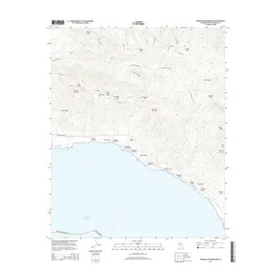
2015 Map of Tranquillon Mountain
USGS Topo · Published 2015About this map
Tranquillon Mtn and the surrounding Santa Ynez Mountains dominate this coastline where the land drops sharply into the Pacific Ocean. This 2015 survey reveals a terrain defined by steep canyons and ridges, including Cypress Ridge and Tranquillon Ridge, which have historically dictated the placement of roads like Honda Ridge Rd and Santa Ynez Ridge Rd. Along the shoreline, the map identifies specific coastal features such as Espada Bluff and the small settlement area of The Espada. The complex drainage system is evidenced by numerous named draws including Cañada Honda Cr, Lompoc Canyon, and Sudden Canyon. These geological features, from Sudden Peak to the various "Cañadas," reflect the area's maritime influence and the rugged physical geography of this part of Santa Barbara County.
Find a feature on this map
51 named features on this map. Tap any name to fly to it.
Don’t see what you’re looking for? This feature index may not catch every label — zoom into the map to look around manually.
Map Details
Editions of this 2015 Tranquillon Mountain Map
This is the sole edition of this map. No revisions or reprints were ever made.
Other maps of this area

1905 · Guadalupe
USGS Topo · 1:125,000

1905 · Lompoc
USGS Topo · 1:125,000

1942 · Point Arguello
USGS Topo · 1:62,500

1942 · Guadalupe
USGS Topo · 1:125,000

1942 · Lompoc
USGS Topo · 1:125,000

1942 · Lompoc
USGS Topo · 1:62,500

1942 · Pt. Conception
USGS Topo · 1:62,500

1943 · Lompoc
USGS Topo · 1:125,000

1947 · Lompoc
USGS Topo · 1:24,000

1947 · Surf
USGS Topo · 1:24,000