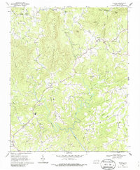
1968 Map of Traphill
USGS Topo · Published 1987About this map
The Roaring River curves through the heart of Wilkes County, shaping the rural landscape of North Carolina during the late 1960s. This survey captures a community deeply rooted in its local institutions, evidenced by the high density of country churches and schools that served the surrounding hollows. From Traphill and Dockery in the north to the settlement of Hays in the south, the map reveals a pattern of development closely tied to the ridgelines and watercourses. Educational life is anchored by the North High Sch, while spiritual and social hubs like Roaring River Ch, New Covenant Ch, and Maple Grove Ch are scattered throughout the hills. The terrain is defined by prominent landmarks such as Pole Bridge Gap and Carters Mountain, with numerous branches and prongs including Little Bugaboo Creek feeding the larger river system, providing a detailed look at the region's historical geography.
Find a feature on this map
54 named features on this map. Tap any name to fly to it.
Don’t see what you’re looking for? This feature index may not catch every label — zoom into the map to look around manually.
Map Details
Editions of this 1968 Traphill Map
3 editions found
Other maps of this area

1889 · Wilkesboro
USGS Topo · 1:125,000

1891 · Wilkesboro
USGS Topo · 1:125,000

1891 · Yadkinville
USGS Topo · 1:125,000

1893 · Yadkinville
USGS Topo · 1:125,000

1953 · Winston-Salem
USGS Topo · 1:250,000

1955 · Winston-Salem
USGS Topo · 1:250,000

1962 · Winston-Salem
USGS Topo · 1:250,000

1966 · Roaring River
USGS Topo · 1:24,000

1966 · Wilkesboro
USGS Topo · 1:24,000
1968 · Glade Valley
USGS Topo · 1:24,000