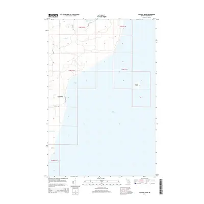
2014 Map of Traverse Island
USGS Topo · Published 2014About this map
Lake Superior dominates this portion of the Keweenaw Peninsula's eastern shoreline, where the water meets the rugged coast of Houghton County. The settlement at Rabbit Bay serves as a focal point for the coastal landscape, situated near where Lahti Cr and Rabbit Beach Rd converge. Further out in the open water lies the isolated Traverse Island, a distinct landform marking the entrance to the larger Keweenaw Bay to the south.
Find a feature on this map
21 named features on this map. Tap any name to fly to it.
Don’t see what you’re looking for? This feature index may not catch every label — zoom into the map to look around manually.
Map Details
Editions of this 2014 Traverse Island Map
This is the sole edition of this map. No revisions or reprints were ever made.
Other maps of this area

1938 · Gay
USGS Topo · 1:31,680

1946 · Laurium
USGS Topo · 1:24,000

1948 · Laurium
USGS Topo · 1:24,000

1954 · Traverse Island
USGS Topo · 1:24,000
1954 · Gay
USGS Topo · 1:24,000
1954 · Rice Lake
USGS Topo · 1:24,000

1954 · Skanee
USGS Topo · 1:62,500

1954 · Keweenaw Bay
USGS Topo · 1:62,500

1954 · Point Mills
USGS Topo · 1:24,000

1958 · Hancock
USGS Topo · 1:250,000