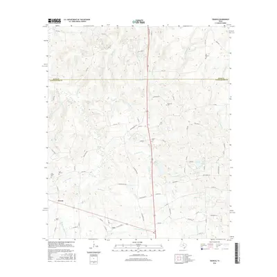
2016 Map of Trawick
USGS Topo · Published 2016About this map
Trawick and Caro anchor this portion of East Texas, where the landscape is defined by the dense network of creeks feeding the Angelina River basin. The survey reveals a region deeply rooted in local family history, as evidenced by numerous small burial grounds including Old Prospect Cem, Helpenstell Cem, and Linn Flat Cem. Water is a constant presence, with larger bodies like Jackson Lake and Langford Lake punctuating the drainages of Beech Cr and Naconiche Cr. The terrain is crisscrossed by established routes such as the Old Henderson Hwy and Old Tyler Rd, which trace the higher ground between the many branches of Pen Cr and Bogg Br. This map provides a detailed look at the rural settlement patterns and hydrological features along the border of Nacogdoches and Rusk Counties.
Find a feature on this map
96 named features on this map. Tap any name to fly to it.
Don’t see what you’re looking for? This feature index may not catch every label — zoom into the map to look around manually.
Map Details
Editions of this 2016 Trawick Map
This is the sole edition of this map. No revisions or reprints were ever made.
Other maps of this area

1943 · Cushing
USGS Topo · 1:62,500

1945 · Cushing
USGS Topo · 1:62,500

1952 · Douglass
USGS Topo · 1:62,500

1952 · Nacogdoches
USGS Topo · 1:62,500

1953 · Palestine
USGS Topo · 1:250,000

1957 · Palestine
USGS Topo · 1:250,000

1960 · Mount Enterprise
USGS Topo · 1:62,500

1973 · Cushing
USGS Topo · 1:24,000
1973 · Laneville
USGS Topo · 1:24,000
1983 · Lake Nacogdoches North
USGS Topo · 1:24,000