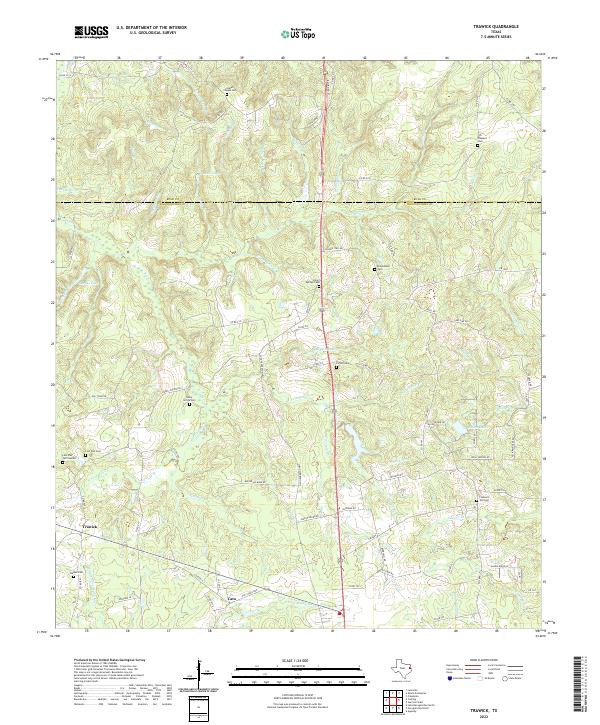
2022 Map of Trawick
USGS Topo · Published 2022About this map
Trawick and Caro anchor this portion of East Texas, where the landscape is defined by the winding tributaries of Middle Fork Bayou Loco and E Fork Bayou Loco. The region is marked by numerous family and community cemeteries, such as Linn Flat Cem and Isabell Chapel Cem, reflecting a deep-rooted pattern of rural settlement. The terrain is a network of small creeks like Beech Cr and Vardeman Br that feed into larger basins. Local history is etched into the road names, from Old Tyler Rd to the loops of Old Caro Loop, tracing the movement of people and goods through the piney woods. Water features like Jackson Lake and Barnes Lake appear as quiet landmarks in a landscape otherwise dominated by timber and small-scale agriculture.
Find a feature on this map
96 named features on this map. Tap any name to fly to it.
Don’t see what you’re looking for? This feature index may not catch every label — zoom into the map to look around manually.
Map Details
Editions of this 2022 Trawick Map
This is the sole edition of this map. No revisions or reprints were ever made.
Other maps of this area

1943 · Cushing
USGS Topo · 1:62,500

1945 · Cushing
USGS Topo · 1:62,500

1952 · Douglass
USGS Topo · 1:62,500

1952 · Nacogdoches
USGS Topo · 1:62,500

1953 · Palestine
USGS Topo · 1:250,000

1957 · Palestine
USGS Topo · 1:250,000

1960 · Mount Enterprise
USGS Topo · 1:62,500

1973 · Cushing
USGS Topo · 1:24,000
1973 · Laneville
USGS Topo · 1:24,000
1983 · Lake Nacogdoches North
USGS Topo · 1:24,000