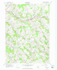
1943 Map of Treadwell
USGS Topo · Published 1974About this map
Treadwell and the surrounding highlands of Delaware County are defined by a network of steep-sided hollows and upland dairy country during the early 1940s. The settlement pattern follows the drainage of Ouleout Creek and Treadwell Creek, where hamlets like West Meredith and Leonta serve as local hubs. This survey, completed just as the Army Map Service was preparing for civil publication, records a high density of rural schoolhouses, including School No 11, School No 5, and several named for their specific hollows, such as Stoodley Hollow Sch. These one-room institutions, paired with landmarks like the Croton Union Cem, provide a precise record of the mid-century social geography in the towns of Franklin, Meredith, and Hamden. The terrain is marked by prominent heights like Jackson Hill and Waterman Peak, while the southern reaches descend toward the flats of Mundale along East Brook.
Find a feature on this map
42 named features on this map. Tap any name to fly to it.
Don’t see what you’re looking for? This feature index may not catch every label — zoom into the map to look around manually.
Map Details
Editions of this 1943 Treadwell Map
3 editions found
Other maps of this area

1909 · Delhi
USGS Topo · 1:62,500

1911 · Delhi
USGS Topo · 1:62,500

1915 · Oneonta
USGS Topo · 1:62,500

1918 · Oneonta
USGS Topo · 1:62,500

1922 · Andes
USGS Topo · 1:62,500

1923 · Walton
USGS Topo · 1:48,000

1924 · Andes
USGS Topo · 1:62,500

1925 · Walton
USGS Topo · 1:62,500

1943 · Delhi
USGS Topo · 1:24,000

1943 · Franklin
USGS Topo · 1:24,000