
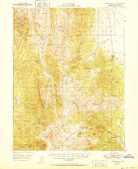
1950 Map of Treasure Hill
USGS Topo · Published 1950About this map
Treasure Hill stands as the centerpiece of this high-altitude landscape, its slopes scarred by a dense concentration of late 19th-century mining infrastructure including the Hidden Treasure Mine, Stafford Shaft, and Wheeler Tunnel. The nearby Eberhardt (Site) and the Treasure Cem indicate the footprint of a once-active silver mining community that thrived before the turn of the century. To the east, the terrain transitions into the wide expanse of Jakes Valley, while the southern reaches are dominated by the Nevada National Forest. The map documents a complex system of natural springs and man-made water improvements like Deadman Res and Mustang Spr Res, which were critical for both the extraction industry and the livestock operations that followed. From the Mokomoke Mountains to the Ellison Ranger Sta, the survey captures the lingering infrastructure of the White Pine mining boom.
Find a feature on this map
56 named features on this map. Tap any name to fly to it.
Don’t see what you’re looking for? This feature index may not catch every label — zoom into the map to look around manually.
Map Details
Editions of this 1950 Treasure Hill Map
2 editions found
Other maps of this area

1949 · Treasure Hill
USGS Topo · 1:62,500

1951 · Green Springs
USGS Topo · 1:62,500

1951 · Illipah
USGS Topo · 1:62,500

1951 · Pancake Summit
USGS Topo · 1:62,500

1956 · Lund
USGS Topo · 1:250,000

1956 · Ely
USGS Topo · 1:250,000

1957 · Currant Mtn
USGS Topo · 1:62,500

1959 · Ely
USGS Topo · 1:250,000

1959 · Reipetown
USGS Topo · 1:62,500

1959 · Preston Reservoir
USGS Topo · 1:62,500