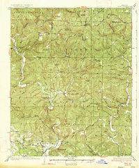
1934 Map of Treat
USGS Topo · Published 1934About this map
Ozark National Forest dominates this mid-1930s landscape, where the deeply carved valleys of Piney Creek and Illinois Bayou dictate the paths of early roads. The area shows a dispersed pattern of rural community life, marked by numerous small district schools such as Ross Sch and Beech Grove Sch. Near the northern boundary, the settlement of Sand Gap (Pelsor PO) serves as a vital junction on the Dillen Highway.
Find a feature on this map
80 named features on this map. Tap any name to fly to it.
Don’t see what you’re looking for? This feature index may not catch every label — zoom into the map to look around manually.
Map Details
Editions of this 1934 Treat Map
3 editions found

Other maps of this area

1879 · Washington
USGS Topo · 1:62,500

1887 · Smyrna
USGS Topo · 1:62,500

1888 · Dardanelle #2
USGS Topo · 1:62,500

1888 · Dardanelle #1
USGS Topo · 1:62,500

1889 · Treat
USGS Topo · 1:62,500

1889 · Marshall #3
USGS Topo · 1:62,500

1889 · Ozone
USGS Topo · 1:62,500

1890 · Dardanelle
USGS Topo · 1:125,000

1892 · Marshall
USGS Topo · 1:125,000

1892 · Morrillton
USGS Topo · 1:125,000