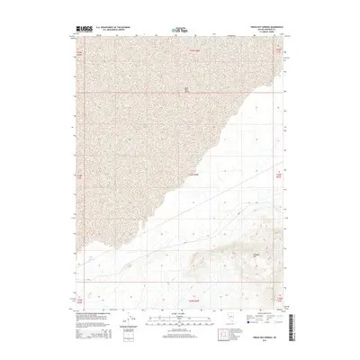
2015 Map of Trego Hot Springs
USGS Topo · Published 2015About this map
Trego Hot Springs emerges as a focal point in this high-desert landscape of northwestern Nevada, marking a rare geothermal feature in an otherwise arid expanse. The map illustrates the sharp topographical transition from the flat, alkaline reach of the Black Rock Desert to the rising elevations of Pahsupp Mtn in the southeast. This intersection of geography defines the area, where the vast playa meets the steep contours of the surrounding mountains. Surface travel is largely confined to NV-49, which skirts the southern edge of the desert floor. The surveying by the U.S. Geological Survey reflects the enduring isolation of this Pershing County corridor, emphasizing the sparse human footprint and the dominance of the natural terrain in the early 21st century.
Find a feature on this map
13 named features on this map. Tap any name to fly to it.
Don’t see what you’re looking for? This feature index may not catch every label — zoom into the map to look around manually.
Map Details
Editions of this 2015 Trego Hot Springs Map
This is the sole edition of this map. No revisions or reprints were ever made.
Other maps of this area

1886 · Granite Range
USGS Topo · 1:250,000

1894 · Granite Range
USGS Topo · 1:250,000

1931 · Lovelock
USGS Topo · 1:250,000

1935 · Lovelock
USGS Topo · 1:250,000

1955 · Lovelock
USGS Topo · 1:250,000

1959 · Lovelock
USGS Topo · 1:250,000

1980 · Dry Mountain NW
USGS Topo · 1:24,000
1980 · Black Rock Point West
USGS Topo · 1:24,000
1980 · Trego Hot Spring
USGS Topo · 1:24,000

1980 · Dry Mountain
USGS Topo · 1:24,000