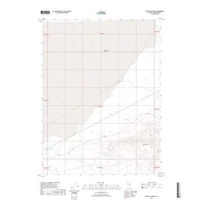
2018 Map of Trego Hot Springs
USGS Topo · Published 2018About this map
Trego Hot Springs sits at the southwestern edge of the expansive Black Rock Desert, a key geological and thermal landmark in this remote section of Pershing County. The landscape is characterized by the stark contrast between the flat, alkali playa of the desert and the rising elevations of Pahsupp Mtn to the southeast. Transportation through this arid basin is defined by Jungo Rd, a primary route that skirts the edge of the desert floor. This 2018 survey documents the precise boundary between the basin floor and the rugged slopes of the mountain range, illustrating the hydraulic and thermal features that have long made this site a point of interest for travelers and researchers in the Great Basin region.
Find a feature on this map
13 named features on this map. Tap any name to fly to it.
Don’t see what you’re looking for? This feature index may not catch every label — zoom into the map to look around manually.
Map Details
Editions of this 2018 Trego Hot Springs Map
This is the sole edition of this map. No revisions or reprints were ever made.
Other maps of this area

1886 · Granite Range
USGS Topo · 1:250,000

1894 · Granite Range
USGS Topo · 1:250,000

1931 · Lovelock
USGS Topo · 1:250,000

1935 · Lovelock
USGS Topo · 1:250,000

1955 · Lovelock
USGS Topo · 1:250,000

1959 · Lovelock
USGS Topo · 1:250,000

1980 · Dry Mountain NW
USGS Topo · 1:24,000
1980 · Black Rock Point West
USGS Topo · 1:24,000
1980 · Trego Hot Spring
USGS Topo · 1:24,000

1980 · Dry Mountain
USGS Topo · 1:24,000