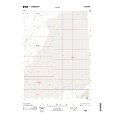
2018 Map of Trego
USGS Topo · Published 2018About this map
Black Rock Desert dominates the vast alkaline flats of Pershing County, Nevada, where the stark topography of the Great Basin is mapped in meticulous detail. The settlement of Trego sits at the southern edge of the desert floor, nestled near the rising slopes of Old Razorback Mtn. This landscape is defined by its scarce but vital water sources, including Lost Spring, Secondhand Spring, and Coyote Spring, which have historically served as critical waypoints for travelers in this arid environment. To the northwest, the prominent peak of Steamboat Mtn provides a stark elevation contrast to the surrounding playa. Remote transportation arteries like Soldier Meadows Rd and Jungo Rd cut across the basin, tracing paths that have likely facilitated movement through this region for generations.
Find a feature on this map
16 named features on this map. Tap any name to fly to it.
Don’t see what you’re looking for? This feature index may not catch every label — zoom into the map to look around manually.
Map Details
Editions of this 2018 Trego Map
This is the sole edition of this map. No revisions or reprints were ever made.
Other maps of this area

1886 · Granite Range
USGS Topo · 1:250,000

1894 · Granite Range
USGS Topo · 1:250,000

1955 · Lovelock
USGS Topo · 1:250,000

1959 · Lovelock
USGS Topo · 1:250,000

1964 · Gerlach
USGS Topo · 1:62,500

1980 · Dry Mountain NW
USGS Topo · 1:24,000
1980 · Black Rock Point West
USGS Topo · 1:24,000
1980 · Trego Hot Spring
USGS Topo · 1:24,000

1980 · Dry Mountain
USGS Topo · 1:24,000
1980 · Hualapai Flat North
USGS Topo · 1:24,000