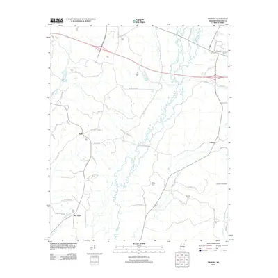
2012 Map of Tremont
USGS Topo · Published 2012About this map
Tremont and the surrounding rural communities of Itawamba County appear here in a landscape defined by small settlements and family burial grounds. The settlement pattern is characterized by several historic focal points including Tilden, Cadamy, and New Salem. The terrain is drained by a dense network of waterways such as Lick Skillet Cr and Johns Cr, which wind through the eastern Mississippi hills. Genealogists will find a high density of rural cemeteries, such as Clover Ridge Cem, Old Mount Pisgah Cem, and Kennedy Cem, reflecting generations of local family residency. Landmarks like the Hopewell Lookout Tower stand as functional points in the landscape, while the infrastructure is a mix of state routes and named family roads like Wallace Russell Rd and Mattox Perkins Rd, tracing the movement between these upland farms and the central town of Tremont.
Find a feature on this map
79 named features on this map. Tap any name to fly to it.
Don’t see what you’re looking for? This feature index may not catch every label — zoom into the map to look around manually.
Map Details
Editions of this 2012 Tremont Map
This is the sole edition of this map. No revisions or reprints were ever made.
Other maps of this area

1956 · Tupelo
USGS Topo · 1:250,000

1958 · Tupelo
USGS Topo · 1:250,000

1965 · Fulton SE
USGS Topo · 1:24,000

1965 · Fulton
USGS Topo · 1:24,000

1966 · Smithville
USGS Topo · 1:24,000

1966 · Beans Ferry
USGS Topo · 1:24,000

1966 · Turon
USGS Topo · 1:24,000

1966 · Tremont
USGS Topo · 1:24,000
1967 · Shottsville
USGS Topo · 1:24,000
1967 · Bexar
USGS Topo · 1:24,000