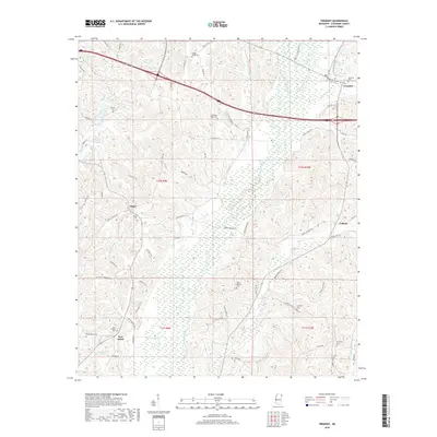
2018 Map of Tremont
USGS Topo · Published 2018About this map
Tremont anchors the northeastern corner of this Itawamba County landscape, where the local road network weaves through a series of creek valleys and ridges. The presence of numerous burial grounds, such as Clover Ridge Cem and Old Mount Pisgah Cem, highlights the area's deep-rooted community history and multigenerational family settlements. Small rural hubs like Tilden and New Salem are linked by thoroughfares such as White Springs Rd and Bull Mtn Rd, reflecting a traditional Mississippi land use pattern where homesteads and small gathering places follow the natural drainage of Bull Mountain Creek and its tributaries.
Find a feature on this map
73 named features on this map. Tap any name to fly to it.
Don’t see what you’re looking for? This feature index may not catch every label — zoom into the map to look around manually.
Map Details
Editions of this 2018 Tremont Map
This is the sole edition of this map. No revisions or reprints were ever made.
Other maps of this area

1956 · Tupelo
USGS Topo · 1:250,000

1958 · Tupelo
USGS Topo · 1:250,000

1965 · Fulton SE
USGS Topo · 1:24,000

1965 · Fulton
USGS Topo · 1:24,000

1966 · Smithville
USGS Topo · 1:24,000

1966 · Beans Ferry
USGS Topo · 1:24,000

1966 · Turon
USGS Topo · 1:24,000

1966 · Tremont
USGS Topo · 1:24,000
1967 · Shottsville
USGS Topo · 1:24,000
1967 · Bexar
USGS Topo · 1:24,000