1903 Map of Trent River
USGS Topo · Published 1975About this map
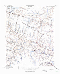
Trent River and its labyrinth of tributary creeks define this coastal plain landscape at the opening of the twentieth century. The river serves as a primary artery for commerce, evidenced by the high concentration of river access points such as White Bank Landing, Wooten Landing, and Murrill Landing. Further inland, the Great Dover Swamp dominates the center of the sheet, crossed by the Atlantic and North Carolina R. R. which connects the settlements of Dover and Cove City. The local infrastructure of the period relies on established crossings like Wilcox Bridge and Perry Bridge, alongside the ancient track of Quaker Bridge Road. Genealogists may find value in the scattered farmsteads and rural nodes such as Phillips Crossroads and Olivers, which provide a detailed record of the Jones and Craven County borderlands before modern development altered these rural townships.
Find a feature on this map
74 named features on this map. Tap any name to fly to it.
Don’t see what you’re looking for? This feature index may not catch every label — zoom into the map to look around manually.
Map Details
Editions of this 1903 Trent River Map
2 editions found
Other maps of this area

1901 · New Bern
USGS Topo · 1:62,500

1902 · Ayden
USGS Topo · 1:62,500

1902 · Vanceboro
USGS Topo · 1:62,500

1903 · New Bern
USGS Topo · 1:62,500

1903 · Trent River
USGS Topo · 1:62,500

1904 · Ayden
USGS Topo · 1:62,500

1904 · Trent River
USGS Topo · 1:62,500

1904 · Vanceboro
USGS Topo · 1:62,500

1905 · Vanceboro
USGS Topo · 1:62,500

1914 · Kinston
USGS Topo · 1:48,000