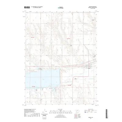
2017 Map of Trenton
USGS Topo · Published 2017About this map
Trenton serves as the focal point of this Hitchcock County landscape, situated along the northern bank of the Republican River and the eastern edge of Swanson Lake. The town's grid is detailed with street names like W G St and E D St, indicating its local importance as a regional hub. To the north, the land is deeply carved by numerous drainages, most notably Massacre Canyon and Hidy Canyon, which break the high plains terrain. Local history is anchored by several burial grounds, including Trenton Cem, Saint James Cem, and the more isolated Rosefield Cem to the southwest. The presence of the Upper Meeker Canal and Canal Rd highlights the vital role of water management and irrigation in this plains environment. To the south, Spring Canyon and Jones Canyon further define the undulating topography surrounding the expansive reservoir.
Find a feature on this map
50 named features on this map. Tap any name to fly to it.
Don’t see what you’re looking for? This feature index may not catch every label — zoom into the map to look around manually.
Map Details
Editions of this 2017 Trenton Map
This is the sole edition of this map. No revisions or reprints were ever made.
Other maps of this area

1954 · McCook
USGS Topo · 1:250,000

1957 · McCook
USGS Topo · 1:250,000

1958 · McCook
USGS Topo · 1:250,000

1962 · Trenton
USGS Topo · 1:24,000

1962 · Trenton SW
USGS Topo · 1:24,000

1962 · Culbertson NW
USGS Topo · 1:24,000

1962 · Culbertson SW
USGS Topo · 1:24,000
1962 · Trenton SE
USGS Topo · 1:24,000

1962 · Stratton
USGS Topo · 1:24,000

1973 · Palisade
USGS Topo · 1:24,000