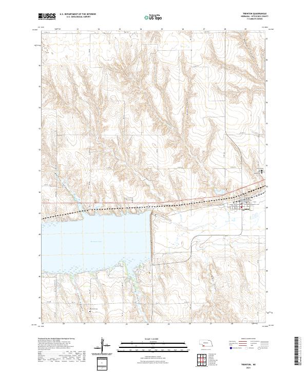
2021 Map of Trenton
USGS Topo · Published 2021About this map
Trenton sits as a central hub on the northern shore of Swanson Lake, serving as the seat of local government with the Hitchcock County Courthouse located at its core. The town layout is defined by a traditional grid, featuring streets like W D St and E G St, positioned just north of the lake's expansive waters. The surrounding Nebraska landscape is heavily dissected by numerous steep-walled drainages including Massacre Canyon, Hidy Canyon, and Macklin Canyon, which carve through the high plains topography north of the reservoir. To the south and west, Jones Canyon and Spring Canyon further define the rugged terrain. Local heritage is preserved at several sites, such as Trenton Cem, Saint James Cem, and the more remote Rosefield Cem to the southwest. This area illustrates the adaptation of a high-plains community to a landscape dominated by major water management and the erosion patterns of the Republican River valley.
Find a feature on this map
34 named features on this map. Tap any name to fly to it.
Don’t see what you’re looking for? This feature index may not catch every label — zoom into the map to look around manually.
Map Details
Editions of this 2021 Trenton Map
This is the sole edition of this map. No revisions or reprints were ever made.
Other maps of this area

1954 · McCook
USGS Topo · 1:250,000

1957 · McCook
USGS Topo · 1:250,000

1958 · McCook
USGS Topo · 1:250,000

1962 · Trenton
USGS Topo · 1:24,000

1962 · Trenton SW
USGS Topo · 1:24,000

1962 · Culbertson NW
USGS Topo · 1:24,000

1962 · Culbertson SW
USGS Topo · 1:24,000
1962 · Trenton SE
USGS Topo · 1:24,000

1962 · Stratton
USGS Topo · 1:24,000

1973 · Palisade
USGS Topo · 1:24,000