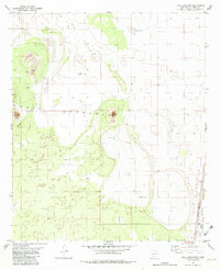
1982 Map of Tres Hermanos
USGS Topo · Published 1982About this map
Tres Hermanos rises from the desert floor in this early 1980s topographical study of the Otero County landscape. The area is defined by its arid geography and the strategic presence of the Fort Bliss Military Reservation (Mc Gregor Range) which occupies the eastern edge of the quadrangle. Distinctive volcanic features like Twin Buttes and Lone Butte provide topographic relief against a series of scattered catchments including Squaw Tank, North Tank, and Desert Tank. These water features indicate the managed nature of this dry rangeland during the late twentieth century. Industry and infrastructure are represented by the Southern Pacific railroad line skirting the military boundary, alongside localized operations such as a Gravel Pit and a mining Prospect. This map captures a specific moment in the Chihuahuan Desert where military expansion, transportation, and natural landforms intersect.
Find a feature on this map
14 named features on this map. Tap any name to fly to it.
Don’t see what you’re looking for? This feature index may not catch every label — zoom into the map to look around manually.
Map Details
Editions of this 1982 Tres Hermanos Map
This is the sole edition of this map. No revisions or reprints were ever made.
Other maps of this area

1916 · Point Of Sands
USGS Topo · 1:125,000

1948 · Tres Hermanos
USGS Topo · 1:62,500

1948 · Holloman
USGS Topo · 1:62,500

1950 · Escondido Canyon
USGS Topo · 1:62,500

1950 · Alamogordo
USGS Topo · 1:62,500

1954 · Carlsbad
USGS Topo · 1:250,000

1955 · Las Cruces
USGS Topo · 1:250,000

1958 · Las Cruces
USGS Topo · 1:250,000

1958 · Carlsbad
USGS Topo · 1:250,000

1976 · Mule Peak
USGS Topo · 1:24,000