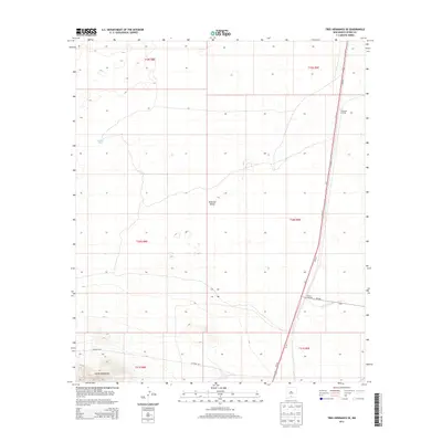
2013 Map of Tres Hermanos SE
USGS Topo · Published 2013About this map
The high desert terrain of the Jarilla Mountains rises in the southwestern corner of this survey, overlooking the expansive floor of the Tularosa Valley. This 2011 imagery-based map captures a landscape defined by significant transit corridors and water management in a dry environment. The eastern edge is dominated by the long stretch of Us-54 S, a primary regional artery that intersects with NM-506 at Paxton Crossing. Further north, Escondida Crossing marks another key navigational point along the highway. In the more open valley floor, features like Moody Tank and a network of section roads including Co Road A011 reveal the underlying infrastructure of the Public Land Survey System, which divides the region into township and range blocks such as t20s r9e.
Find a feature on this map
15 named features on this map. Tap any name to fly to it.
Don’t see what you’re looking for? This feature index may not catch every label — zoom into the map to look around manually.
Map Details
Editions of this 2013 Tres Hermanos SE Map
This is the sole edition of this map. No revisions or reprints were ever made.
Other maps of this area

1916 · Point Of Sands
USGS Topo · 1:125,000

1940 · Orogrande
USGS Topo · 1:62,500

1943 · Pendejo Wash
USGS Topo · 1:62,500

1943 · Orogrande
USGS Topo · 1:62,500

1947 · Orogrande North
USGS Topo · 1:24,000

1948 · Elephant Mountain
USGS Topo · 1:24,000

1948 · Tres Hermanos
USGS Topo · 1:62,500

1950 · Escondido Canyon
USGS Topo · 1:62,500

1954 · Carlsbad
USGS Topo · 1:250,000
1955 · Elephant Mountain
USGS Topo · 1:24,000