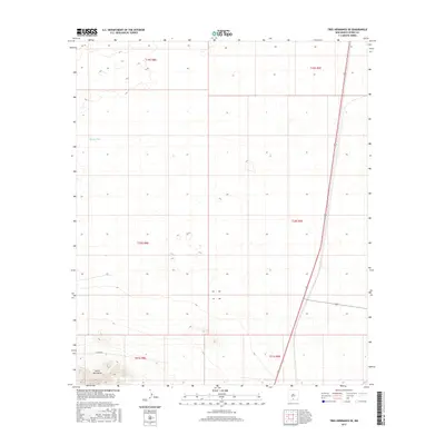
2017 Map of Tres Hermanos SE
USGS Topo · Published 2017About this map
The Jarilla Mountains rise in the southwestern corner of this high-desert Otero County landscape, providing the primary topographic relief in an area otherwise defined by vast drainage basins. The arid environment is punctuated by isolated water management features like Moody Tank, essential for sustaining life and livestock in this corner of New Mexico. Human infrastructure is dominated by the long north-south corridor of Route 54, which cuts a straight line through the eastern sections, and Co Rd A011, which skirts the base of the mountains. This 2017 survey details the Public Land Survey System grid across multiple townships, including t20s r8e and t21s r9e, illustrating how the desert floor has been partitioned into expansive rectangular tracts for ranching and resource management.
Find a feature on this map
11 named features on this map. Tap any name to fly to it.
Don’t see what you’re looking for? This feature index may not catch every label — zoom into the map to look around manually.
Map Details
Editions of this 2017 Tres Hermanos SE Map
This is the sole edition of this map. No revisions or reprints were ever made.
Other maps of this area

1916 · Point Of Sands
USGS Topo · 1:125,000

1940 · Orogrande
USGS Topo · 1:62,500

1943 · Pendejo Wash
USGS Topo · 1:62,500

1943 · Orogrande
USGS Topo · 1:62,500

1947 · Orogrande North
USGS Topo · 1:24,000

1948 · Elephant Mountain
USGS Topo · 1:24,000

1948 · Tres Hermanos
USGS Topo · 1:62,500

1950 · Escondido Canyon
USGS Topo · 1:62,500

1954 · Carlsbad
USGS Topo · 1:250,000
1955 · Elephant Mountain
USGS Topo · 1:24,000