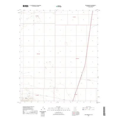
2020 Map of Tres Hermanos SE
USGS Topo · Published 2020About this map
The Jarilla Mountains dominate the southwestern corner of this high-desert Otero County landscape, rising sharply from the surrounding basins. This 2020 survey of the Tres Hermanos SE quadrangle captures a largely undeveloped stretch of public and private land defined by the surveyed grid lines of the Public Land Survey System, including t20s r8e and t21s r9e. Transportation through this arid region is anchored by the Owen Prather Hwy, which cuts a nearly straight diagonal path across the southeastern portion of the map. Away from this primary route, travel is limited to local tracks such as Co Rd A011, which skirts the northern edge of the mountains, illustrating the sparse infrastructure common to this portion of New Mexico.
Find a feature on this map
9 named features on this map. Tap any name to fly to it.
Don’t see what you’re looking for? This feature index may not catch every label — zoom into the map to look around manually.
Map Details
Editions of this 2020 Tres Hermanos SE Map
This is the sole edition of this map. No revisions or reprints were ever made.
Other maps of this area

1916 · Point Of Sands
USGS Topo · 1:125,000

1940 · Orogrande
USGS Topo · 1:62,500

1943 · Pendejo Wash
USGS Topo · 1:62,500

1943 · Orogrande
USGS Topo · 1:62,500

1947 · Orogrande North
USGS Topo · 1:24,000

1948 · Elephant Mountain
USGS Topo · 1:24,000

1948 · Tres Hermanos
USGS Topo · 1:62,500

1950 · Escondido Canyon
USGS Topo · 1:62,500

1954 · Carlsbad
USGS Topo · 1:250,000
1955 · Elephant Mountain
USGS Topo · 1:24,000