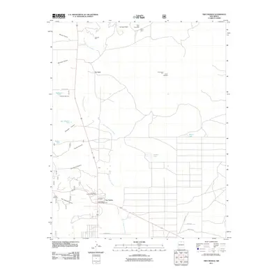
2011 Map of Tres Piedras
USGS Topo · Published 2011About this map
Tres Piedras stands as a focal point in this high-altitude landscape, marked by its role as a regional service hub with the Tres Piedras District Ranger Office, the Tres Piedras Post Office, and a visible remnant of steam-era transportation, the Tres Piedras Railroad Water Tower. The terrain is defined by the sweeping Arroyo Aguaje de la Petaca and the volcanic prominence of Cerro del Aire. Industrial activity is heavily represented to the north near No Agua, where numerous perlite operations including the United Perlite Mine and Seven Hills Perlite Mine suggest a landscape shaped by mineral extraction. This 2011 survey also captures several named tanks like Agropyron Tank and Palmer Tank, essential water sources for the cattle ranching and land management practices common to this part of northern New Mexico.
Find a feature on this map
29 named features on this map. Tap any name to fly to it.
Don’t see what you’re looking for? This feature index may not catch every label — zoom into the map to look around manually.
Map Details
Editions of this 2011 Tres Piedras Map
This is the sole edition of this map. No revisions or reprints were ever made.
Other maps of this area

1918 · Tusas
USGS Topo · 1:125,000

1954 · Raton
USGS Topo · 1:250,000

1954 · Aztec
USGS Topo · 1:250,000

1958 · Raton
USGS Topo · 1:250,000

1958 · Aztec
USGS Topo · 1:250,000

1962 · Aztec
USGS Topo · 1:250,000
1963 · Las Tablas
USGS Topo · 1:24,000

1963 · Tres Piedras NE
USGS Topo · 1:24,000

1963 · Cerro De La Olla
USGS Topo · 1:24,000

1963 · Cerro De Los Taoses
USGS Topo · 1:24,000