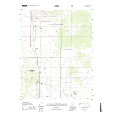
2020 Map of Tres Piedras
USGS Topo · Published 2020About this map
The high volcanic plateau of northern New Mexico is prominently displayed on this 2020 map, centered on the settlement of Tres Piedras. This area of Taos County is characterized by significant topographic rises like the Cerro del Aire and the No Agua Peaks, landmarks that define the horizon within the Río Grande del Norte National Monument. The landscape is etched by numerous drainage features, most notably the Arroyo Aguaje de la Petaca and several named canyons such as Barela Canyon and Martinez Canyon.
Find a feature on this map
36 named features on this map. Tap any name to fly to it.
Don’t see what you’re looking for? This feature index may not catch every label — zoom into the map to look around manually.
Map Details
Editions of this 2020 Tres Piedras Map
This is the sole edition of this map. No revisions or reprints were ever made.
Other maps of this area

1918 · Tusas
USGS Topo · 1:125,000

1954 · Raton
USGS Topo · 1:250,000

1954 · Aztec
USGS Topo · 1:250,000

1958 · Raton
USGS Topo · 1:250,000

1958 · Aztec
USGS Topo · 1:250,000

1962 · Aztec
USGS Topo · 1:250,000
1963 · Las Tablas
USGS Topo · 1:24,000

1963 · Tres Piedras NE
USGS Topo · 1:24,000

1963 · Cerro De La Olla
USGS Topo · 1:24,000

1963 · Cerro De Los Taoses
USGS Topo · 1:24,000