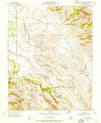
1955 Map of Tres Pinos
USGS Topo · Published 1956About this map
Hollister Valley and the surrounding foothill ranges define this 1955 landscape, where agriculture and ranching follow the path of the San Benito River and Tres Pinos Creek. The small community of Tres Pinos stands as a central point for the region, while rural life is anchored by a series of schoolhouses including Enterprise Sch, Southside Sch, and Santa Ana School. The map captures the mid-century transportation network with routes like the Airline Highway and South Side Road connecting remote ranchlands such as Indart Ranch to the valley floor.
Find a feature on this map
28 named features on this map. Tap any name to fly to it.
Don’t see what you’re looking for? This feature index may not catch every label — zoom into the map to look around manually.
Map Details
Editions of this 1955 Tres Pinos Map
4 editions found
Other maps of this area

1919 · San Benito
USGS Topo · 1:62,500

1919 · Hollister
USGS Topo · 1:48,000

1921 · Gonzales
USGS Topo · 1:62,500

1921 · Hollister
USGS Topo · 1:62,500

1922 · Quien Sabe
USGS Topo · 1:62,500

1923 · Hollister
USGS Topo · 1:62,500

1931 · San Benito
USGS Topo · 1:62,500

1940 · Hollister
USGS Topo · 1:62,500

1940 · Quien Sabe
USGS Topo · 1:62,500

1940 · San Benito
USGS Topo · 1:62,500