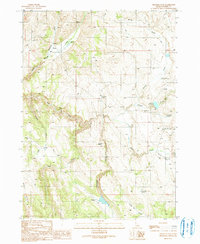
1990 Map of Triangle Flat
USGS Topo · Published 1991About this map
Triangle Flat and the high desert of Owyhee County are defined by a network of seasonal water sources and early mining traces. In the northern reaches, a Mine Shaft and Adit near Mammoth Creek mark where prospecting met the high plateau. The landscape transitions into deep drainages like Josephine Creek and Rock Creek, which flow toward the southern valleys. Settlement remains sparse, with human activity centered on ranching infrastructure such as the Spencer Reservoir and Twin Valley Reservoir. This environment required significant resource management, evidenced by the numerous named water points including Hardman Spring and Chimney Spring. In the southeast, the Triangle Airstrip and Antelope Ridge Road provide the primary links across this high-elevation terrain, connecting the open flats with the prominent Rose Ridge.
Find a feature on this map
28 named features on this map. Tap any name to fly to it.
Don’t see what you’re looking for? This feature index may not catch every label — zoom into the map to look around manually.
Map Details
Editions of this 1990 Triangle Flat Map
This is the sole edition of this map. No revisions or reprints were ever made.
Other maps of this area

1955 · Jordan Valley
USGS Topo · 1:250,000

1957 · Jordan Valley
USGS Topo · 1:250,000

1958 · Jordan Valley
USGS Topo · 1:250,000

1965 · Triangle
USGS Topo · 1:62,500

1965 · Flint Creek
USGS Topo · 1:62,500

1973 · Indian Meadows
USGS Topo · 1:24,000

1973 · Hurry Up Creek
USGS Topo · 1:24,000

1973 · Wickiup Creek
USGS Topo · 1:24,000
1990 · Triangle
USGS Topo · 1:100,000
1990 · Toy Pass
USGS Topo · 1:24,000