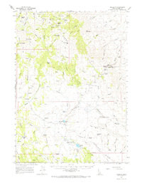
1965 Map of Triangle
USGS Topo · Published 1967About this map
The Silver City Range dominates this mid-1960s landscape, illustrating the high-desert mining and ranching geography of Owyhee County. Mining activity is evident through sites like the Affehtought Mine and numerous prospect markers, particularly around peaks with mineral-driven names like Cinnabar Mtn and Quicksilver Mtn. These peaks are connected by a network of jeep trails that navigate difficult passes such as Toy Pass and Pickett Creek Saddle.
Find a feature on this map
62 named features on this map. Tap any name to fly to it.
Don’t see what you’re looking for? This feature index may not catch every label — zoom into the map to look around manually.
Map Details
Editions of this 1965 Triangle Map
2 editions found

Other maps of this area

1892 · Bisuka
USGS Topo · 1:125,000

1892 · Silver City
USGS Topo · 1:125,000

1894 · Bisuka
USGS Topo · 1:125,000

1894 · Silver City
USGS Topo · 1:125,000

1898 · Silver City
USGS Topo · 1:125,000

1949 · Oreana
USGS Topo · 1:62,500
1949 · Oreana
USGS Topo · 1:24,000
1950 · Oreana
USGS Topo · 1:24,000

1955 · Jordan Valley
USGS Topo · 1:250,000

1955 · Boise
USGS Topo · 1:250,000