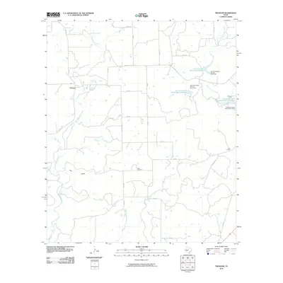
2010 Map of Trickham
USGS Topo · Published 2010About this map
Trickham and its surrounding ranchlands in Coleman County appear here as they were documented in the early twenty-first century. The landscape is defined by the winding course of Mukewater Creek and its tributaries, including Hay Creek and Boggy Creek. This area of central Texas shows a distinct pattern of land management through a series of water control structures, including the Soil Conservation Service Site 1 Reservoir, Soil Conservation Service Site 2 Reservoir, and Soil Conservation Service Site 3 Reservoir, each with its own corresponding dam. For genealogists and local historians, several family-named landmarks are preserved on the sheet, including the Rice Cemetery near the center and Lee Cemetery and Smith Cemetery further east. The terrain is marked by the presence of Deer Hollow, while the road network is a grid of county routes like Co RD 217 and cattle-specific paths such as Cattleguard Rd.
Find a feature on this map
36 named features on this map. Tap any name to fly to it.
Don’t see what you’re looking for? This feature index may not catch every label — zoom into the map to look around manually.
Map Details
Editions of this 2010 Trickham Map
This is the sole edition of this map. No revisions or reprints were ever made.
Other maps of this area

1887 · Coleman
USGS Topo · 1:125,000

1889 · Coleman
USGS Topo · 1:125,000

1894 · Brady
USGS Topo · 1:125,000

1924 · Brady 2-a
USGS Topo · 1:48,000

1925 · Brady 1-b
USGS Topo · 1:48,000

1925 · Brady 1-a
USGS Topo · 1:48,000

1928 · Mercury
USGS Topo · 1:62,500

1928 · Waldrip
USGS Topo · 1:62,500

1950 · Mercury
USGS Topo · 1:62,500

1954 · Brownwood
USGS Topo · 1:250,000