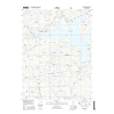
2015 Map of Trinity Dam
USGS Topo · Published 2015About this map
Trinity Lake dominates this rugged portion of the Trinity National Forest, serving as a central geographic feature that dictates the surrounding settlement and road patterns. This 2015 data reflects a landscape defined by water management and recreation, where small communities like Ridgeville, Estrellita, and Fairview are situated near the fingers of the reservoir. The massive Trinity Dam and its lower neighbor, Lewiston Lake, indicate the area's role in California's water infrastructure. Beyond the water, the terrain ascends sharply into the Salmon Mountains and notable peaks such as Pettijohn Mtn. Genealogists and local historians will find the Ridgeville Cemetery and family-named landmarks like Bowerman Ridge or Roycroft Gulch essential for tracking local roots. A network of forest routes, including Haylock Ridge Rd and Montgomery Creek Rd, provides detail on access to remote corners of this mountain landscape.
Find a feature on this map
79 named features on this map. Tap any name to fly to it.
Don’t see what you’re looking for? This feature index may not catch every label — zoom into the map to look around manually.
Map Details
Editions of this 2015 Trinity Dam Map
This is the sole edition of this map. No revisions or reprints were ever made.
Other maps of this area

1890 · Red Bluff
USGS Topo · 1:250,000

1894 · Red Bluff
USGS Topo · 1:250,000

1913 · Weaverville
USGS Topo · 1:125,000

1944 · French Gulch
USGS Topo · 1:62,500

1948 · French Gulch
USGS Topo · 1:62,500

1950 · Minersville
USGS Topo · 1:62,500

1950 · Schell Mtn
USGS Topo · 1:62,500

1950 · Weaverville
USGS Topo · 1:62,500
1952 · Schell Mtn.
USGS Topo · 1:62,500

1952 · Weaverville
USGS Topo · 1:62,500