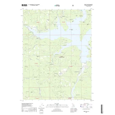
2018 Map of Trinity Dam
USGS Topo · Published 2018About this map
Trinity Lake dominates this portion of the Trinity National Forest, where the construction of the Trinity Dam fundamentally altered the local topography. The waters of the reservoir have filled numerous drainages once defined by gold-rush era activity, leaving behind features like the Ridgeville Islands and the submerged history of the former settlement at Ridgeville. High above the water line, the Ridgeville Cem and the summit of Pettijohn Mtn remain as permanent fixtures of the Trinity County landscape. The map reveals a complex network of forest routes, including Trinity Dam Blvd and Trinity Lake Blvd, which provide access to the steep ridges of the Salmon Mountains. This late-stage survey preserves the names of countless gulches and flats, such as Red Flat and Tannery Gulch, that reflect the region's rugged timber and mining heritage.
Find a feature on this map
75 named features on this map. Tap any name to fly to it.
Don’t see what you’re looking for? This feature index may not catch every label — zoom into the map to look around manually.
Map Details
Editions of this 2018 Trinity Dam Map
This is the sole edition of this map. No revisions or reprints were ever made.
Other maps of this area

1890 · Red Bluff
USGS Topo · 1:250,000

1894 · Red Bluff
USGS Topo · 1:250,000

1913 · Weaverville
USGS Topo · 1:125,000

1944 · French Gulch
USGS Topo · 1:62,500

1948 · French Gulch
USGS Topo · 1:62,500

1950 · Minersville
USGS Topo · 1:62,500

1950 · Schell Mtn
USGS Topo · 1:62,500

1950 · Weaverville
USGS Topo · 1:62,500
1952 · Schell Mtn.
USGS Topo · 1:62,500

1952 · Weaverville
USGS Topo · 1:62,500