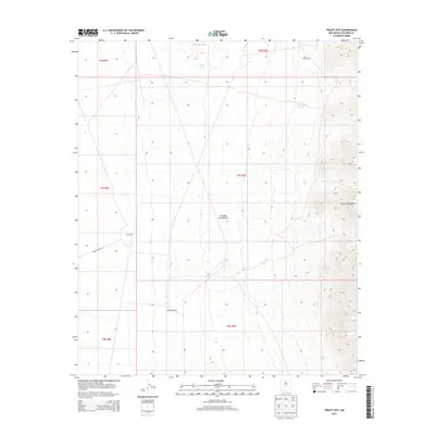
2013 Map of Trinity Site
USGS Topo · Published 2013About this map
The Trinity Site stands as the central landmark of this landscape, situated within the vast arid basin of the Jornada del Muerto. This location in Socorro County is where the world’s first nuclear device was detonated, an event that fundamentally changed the course of history. To the south, the McDonald Ranch house represents the rural ranching heritage that existed before the area was repurposed for government testing. The terrain is defined by the sharp ascent of the Oscura Mountains on the eastern edge of the quadrangle, where Trail Canyon cuts through the ridges. Water sources are scarce in this high desert environment, marked by small catchments such as Little Red Tank, Story Tank, and Story E Tank. Transportation through this controlled space is limited to specific corridors like Wsmr P Route 20, reflecting the region's transition from open range to a highly restricted military zone.
Find a feature on this map
16 named features on this map. Tap any name to fly to it.
Don’t see what you’re looking for? This feature index may not catch every label — zoom into the map to look around manually.
Map Details
Editions of this 2013 Trinity Site Map
This is the sole edition of this map. No revisions or reprints were ever made.
Other maps of this area

1918 · Oscura Peak
USGS Topo · 1:125,000

1948 · Carthage
USGS Topo · 1:62,500

1948 · Granjean Well
USGS Topo · 1:62,500

1948 · Bingham
USGS Topo · 1:62,500

1948 · Mockingbird Gap
USGS Topo · 1:62,500

1954 · Tularosa
USGS Topo · 1:250,000

1958 · Tularosa
USGS Topo · 1:250,000
1981 · Greens Baber Well
USGS Topo · 1:24,000
1981 · Foster Well
USGS Topo · 1:24,000
1981 · Trinity Site
USGS Topo · 1:24,000