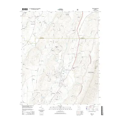
2014 Map of Trion
USGS Topo · Published 2014About this map
The Chattooga River winds through this Northwest Georgia landscape, anchoring a series of small communities between the prominent ridges of Shinbone Ridge and Taylor Ridge. The town of Trion serves as a central hub, flanked by East Trion and the neighboring settlement of Pennville. This area is characterized by its agricultural valleys, such as Dry Valley, and its network of country roads connecting family-named landmarks and rural burying grounds. Genealogists will find a wealth of local history in the numerous cemeteries scattered throughout, including Allgood Cem, Trinity Cem, and Greenhill Memory Garden. On the eastern edge, the topography rises sharply into the Chattooga National Forest, where the Narrows Lookout Tower stands near the Chattooga and Walker County line. The map also captures specialized transport features like the Gibson Field Airport and various small lakes such as Carp Lake and Selmans Lake.
Find a feature on this map
143 named features on this map. Tap any name to fly to it.
Don’t see what you’re looking for? This feature index may not catch every label — zoom into the map to look around manually.
Map Details
Editions of this 2014 Trion Map
This is the sole edition of this map. No revisions or reprints were ever made.
Other maps of this area

1886 · Ringgold
USGS Topo · 1:125,000

1886 · Rome
USGS Topo · 1:125,000

1892 · Ringgold
USGS Topo · 1:125,000

1898 · Rome
USGS Topo · 1:125,000

1899 · Rome
USGS Topo · 1:125,000

1904 · Rome
USGS Topo · 1:125,000

1935 · Catlett
USGS Topo · 1:24,000

1936 · Estelle
USGS Topo · 1:24,000
1936 · Dougherty Gap
USGS Topo · 1:24,000
1936 · Cedar Grove
USGS Topo · 1:24,000