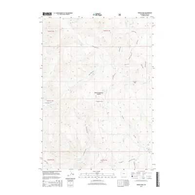
2015 Map of Tripod Peak
USGS Topo · Published 2015About this map
Teton National Forest encompasses the high country of this 2015 survey, dominated by the drainage systems of the Spread Creek and Fish Creek watersheds. The landscape is defined by the prominent Tripod Peak and a dense network of mountain streams including Elkhorn Cr and Hardscrabble Cr. This area represents a managed wilderness environment where historical pack routes like Cottonwood (Pack) provide access through the complex topography. Historical movement through these peaks is evidenced by established transition paths such as the Spruce Creek Cut-Off and the Packsaddle Cut-Off. The map details the intricate hydrography of the region, from the headwaters of S Fork Spread Cr to the southern reaches of Dog Creek and N Fork of Fish Creek, reflecting the importance of water management and forest service access in this part of Wyoming.
Find a feature on this map
41 named features on this map. Tap any name to fly to it.
Don’t see what you’re looking for? This feature index may not catch every label — zoom into the map to look around manually.
Map Details
Editions of this 2015 Tripod Peak Map
This is the sole edition of this map. No revisions or reprints were ever made.
Other maps of this area

1902 · Mt Leidy
USGS Topo · 1:125,000

1955 · Driggs
USGS Topo · 1:250,000

1958 · Driggs
USGS Topo · 1:250,000

1962 · Driggs
USGS Topo · 1:250,000

1965 · Green Mountain
USGS Topo · 1:24,000
1965 · Lava Mountain
USGS Topo · 1:24,000

1965 · Rosies Ridge
USGS Topo · 1:24,000
1965 · Sheridan Pass
USGS Topo · 1:24,000
1965 · Upper Slide Lake
USGS Topo · 1:24,000

1965 · Tripod Peak
USGS Topo · 1:24,000