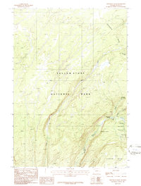
1986 Map of Trischman Knob
USGS Topo · Published 1986About this map
Yellowstone National Park terrain dominates this 1980s survey, defined by the hydrological divide of the Continental Divide and the descent of mountain waters into Bechler Canyon. The landscape is a complex network of drainage and vertical drops, particularly concentrated around the Three River Junction. Here, the Bechler River is fed by tributaries like Phillips Fork and Gregg Fork, creating a series of named waterfalls including Ferris Falls, Tendoy Falls, and Gwinna Falls. To the south, the massive Pitchstone Plateau rises as a prominent landmark, while the namesake Trischman Knob stands near the eastern boundary. The absence of roads is notable, with only a Pack Trail winding through the canyon system. This map provides an essential view of the park's wilderness character before modern digital mapping, capturing the exact placement of remote features like Betchelder Column and Quiver Cascade.
Find a feature on this map
19 named features on this map. Tap any name to fly to it.
Don’t see what you’re looking for? This feature index may not catch every label — zoom into the map to look around manually.
Map Details
Editions of this 1986 Trischman Knob Map
This is the sole edition of this map. No revisions or reprints were ever made.
Other maps of this area

1886 · Shoshone
USGS Topo · 1:125,000

1888 · Shoshone
USGS Topo · 1:125,000

1895 · Shoshone
USGS Topo · 1:125,000

1901 · Shoshone
USGS Topo · 1:125,000

1908 · Shoshone
USGS Topo · 1:125,000

1911 · Shoshone
USGS Topo · 1:125,000

1955 · Ashton
USGS Topo · 1:250,000

1956 · Old Faithful
USGS Topo · 1:62,500

1956 · Grassy Lake Reservoir
USGS Topo · 1:62,500

1957 · Warm River Butte
USGS Topo · 1:62,500