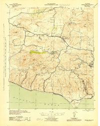
1943 Map of Triunfo Pass
USGS Topo · Published 1943About this map
Thousand Oaks Community and the surrounding Conejo Valley reflect a transitional landscape in the early 1940s, where small settlements and ranching estates dominate the interior terrain before the era of major suburban expansion. The Santa Monica Mountains form a complex backdrop, deeply incised by numerous drainages such as Trancas Canyon and Solstice Canyon that descend toward the Pacific Ocean. Local institutional life is marked by rural schoolhouses including Timber Sch and Cornell Grade Sch, while recreation centers around Lake Sherwood, Malibu Lake, and Seminole Hot Springs. The presence of several large private holdings like Chamberlain Ranch and Trancas Ranch suggests the area's agricultural and pastoral character during this period. Strategic coastal and mountain monitoring is evidenced by the Lechuza Patrol Station and Zuma Patrol Station, highlighting the regional security concerns during the war years.
Find a feature on this map
64 named features on this map. Tap any name to fly to it.
Don’t see what you’re looking for? This feature index may not catch every label — zoom into the map to look around manually.
Map Details
Editions of this 1943 Triunfo Pass Map
This is the sole edition of this map. No revisions or reprints were ever made.
Other maps of this area

1900 · Triunfo Pass
USGS Topo · 1:62,500

1900 · Piru
USGS Topo · 1:62,500

1903 · Santa Paula
USGS Topo · 1:62,500

1903 · Calabasas
USGS Topo · 1:62,500

1903 · Camulos
USGS Topo · 1:125,000

1903 · Santa Susana
USGS Topo · 1:62,500

1904 · Hueneme
USGS Topo · 1:62,500

1921 · Piru
USGS Topo · 1:62,500

1921 · Triunfo Pass
USGS Topo · 1:62,500

1929 · Dume Point
USGS Topo · 1:24,000