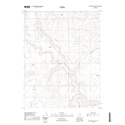
2020 Map of Trough Springs Canyon
USGS Topo · Published 2020About this map
Kane Springs Canyon and Trough Springs Canyon dominate this high-desert landscape in San Juan County, where complex topography creates a labyrinth of drainages and mesas. This 2020 survey illustrates the modern intersection of traditional cattle-country routes and modern recreation, featuring rugged corridors like Behind The Rocks Rd and the 24-Hours Of Moab trail. Landmarks such as The Wine Glass and Hatch Point define the local skyline, while vital water sources like Trough Spring and Kane Springs Cr highlight the sparse but critical hydrology of the region. The map provides a clear look at the network of county roads including Co RD 132 and Hatch Point Rd that navigate between Bridger Jack Mesa and Flat Iron Mesa, essential for understanding the accessibility and land use of this distinct Utah terrain.
Find a feature on this map
17 named features on this map. Tap any name to fly to it.
Don’t see what you’re looking for? This feature index may not catch every label — zoom into the map to look around manually.
Map Details
Editions of this 2020 Trough Springs Canyon Map
This is the sole edition of this map. No revisions or reprints were ever made.
Other maps of this area

1885 · La Sal
USGS Topo · 1:250,000

1952 · Moab 4 SW
USGS Topo · 1:24,000

1954 · Mt Peale 2 SW
USGS Topo · 1:24,000

1954 · Mt Peale 2 NW
USGS Topo · 1:24,000

1954 · Carlisle 1 NE
USGS Topo · 1:24,000

1954 · Carlisle 1 SE
USGS Topo · 1:24,000

1954 · Carlisle 1 NW
USGS Topo · 1:24,000

1954 · Mt. Waas 3 SW
USGS Topo · 1:24,000

1954 · Carlisle 1 SW
USGS Topo · 1:24,000

1954 · La Sal Junction
USGS Topo · 1:62,500