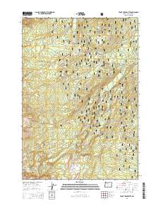
2014 Map of Trout Creek Butte
USGS Topo · Published 2014About this map
Deschutes National Forest encompasses this section of the High Cascades, where volcanic features and glacial drainages define the landscape. The northern portion is dominated by the prominent Trout Creek Butte and the distinct volcanic form of Millican Crater, while the southern reaches transition into the high-elevation wilderness of the Cascade Range. This 2014 survey documents a complex network of forest development roads, such as Pole Creek Rd, that provide access to the backcountry. Water is central to the area's geography, with the headwaters of Whychus Cr and its forks carving through the terrain. Notable hydrologic landmarks include the dramatic Chush Falls and Upper Chush Falls, along with isolated alpine features like Demaris Lake and the open flats of Red Meadow at the southern boundary.
Find a feature on this map
37 named features on this map. Tap any name to fly to it.
Don’t see what you’re looking for? This feature index may not catch every label — zoom into the map to look around manually.
Map Details
Editions of this 2014 Trout Creek Butte Map
This is the sole edition of this map. No revisions or reprints were ever made.
Other maps of this area

1929 · Three Sisters
USGS Topo · 1:125,000

1932 · Three Sisters
USGS Topo · 1:125,000

1955 · Bend
USGS Topo · 1:250,000

1957 · Bend
USGS Topo · 1:250,000

1958 · Bend
USGS Topo · 1:250,000

1959 · Broken Top
USGS Topo · 1:62,500
1959 · Three Sisters
USGS Topo · 1:62,500

1959 · Three Fingered Jack
USGS Topo · 1:62,500

1959 · Sisters
USGS Topo · 1:62,500
1980 · Bend
USGS Topo · 1:100,000