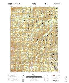
2020 Map of Trout Creek Butte
USGS Topo · Published 2020About this map
The Whychus Creek Wild and Scenic River carves a significant path through this section of the Deschutes National Forest along the eastern slope of the Cascade Range. This landscape is defined by its volcanic geology and high-elevation hydrology, featuring prominent landmarks like Millican Crater and Trout Creek Butte. The presence of several distinct marshlands and water bodies, including the Trout Creek Swamp, Red Meadow, and the basin holding Demaris Lake, suggests a complex drainage system feeding into the Whychus corridor. For those tracing historical movement through the high country, the map identifies several significant passage points and crossings, such as Scott Pass and Twin Meadows. The network of trails, including the lengthy Metolius-Windigo and the specialized Three Creeks Lake XC route, illustrates how this portion of the forest is organized for seasonal access and resource management.
Find a feature on this map
40 named features on this map. Tap any name to fly to it.
Don’t see what you’re looking for? This feature index may not catch every label — zoom into the map to look around manually.
Map Details
Editions of this 2020 Trout Creek Butte Map
This is the sole edition of this map. No revisions or reprints were ever made.
Other maps of this area

1929 · Three Sisters
USGS Topo · 1:125,000

1932 · Three Sisters
USGS Topo · 1:125,000

1955 · Bend
USGS Topo · 1:250,000

1957 · Bend
USGS Topo · 1:250,000

1958 · Bend
USGS Topo · 1:250,000

1959 · Broken Top
USGS Topo · 1:62,500
1959 · Three Sisters
USGS Topo · 1:62,500

1959 · Three Fingered Jack
USGS Topo · 1:62,500

1959 · Sisters
USGS Topo · 1:62,500
1980 · Bend
USGS Topo · 1:100,000