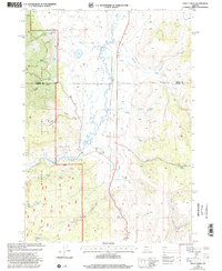
1999 Map of Trout Creek
USGS Topo · Published 2002About this map
Malheur National Forest dominates this high-altitude landscape along the border of Grant and Harney counties. The Silvies River meanders through the central valley, supported by an intricate water management system including a named Aqueduct, multiple dams, and a Weir near the Silvies Valley Ranch. This network suggests a dedicated focus on cattle ranching and irrigation in an otherwise arid environment.
Find a feature on this map
32 named features on this map. Tap any name to fly to it.
Don’t see what you’re looking for? This feature index may not catch every label — zoom into the map to look around manually.
Map Details
Editions of this 1999 Trout Creek Map
This is the sole edition of this map. No revisions or reprints were ever made.
Other maps of this area

1955 · Burns
USGS Topo · 1:250,000

1955 · Canyon City
USGS Topo · 1:250,000

1958 · Burns
USGS Topo · 1:250,000

1959 · Burns
USGS Topo · 1:250,000

1959 · Canyon City
USGS Topo · 1:250,000

1959 · West Myrtle Butte
USGS Topo · 1:62,500

1961 · Calamity Butte
USGS Topo · 1:62,500

1961 · Logdell
USGS Topo · 1:62,500

1961 · Seneca
USGS Topo · 1:62,500

1978 · John Day
USGS Topo · 1:100,000