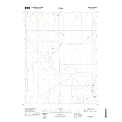
2020 Map of Trout Creek
USGS Topo · Published 2020About this map
Snake Valley dominates this high-desert corridor of Western Utah, where the historic path of the Pony Express Rd and Pony Express Hwy cross the arid basin. The landscape is defined by its seasonal hydrology and geological landmarks, ranging from the southern peaks of the Confusion Range to the distinct volcanic formations of Smelter Knolls. Sparse ranching and transport infrastructure are evidenced by routes like Granite Ranch Rd and Snake Valley Rd, which navigate the wide gaps between water sources.
Find a feature on this map
18 named features on this map. Tap any name to fly to it.
Don’t see what you’re looking for? This feature index may not catch every label — zoom into the map to look around manually.
Map Details
Editions of this 2020 Trout Creek Map
This is the sole edition of this map. No revisions or reprints were ever made.
Other maps of this area

1908 · Fish Springs
USGS Topo · 1:250,000

1910 · Fish Springs
USGS Topo · 1:250,000

1953 · Delta
USGS Topo · 1:250,000

1958 · Delta
USGS Topo · 1:250,000

1960 · Granite Mountain
USGS Topo · 1:62,500

1961 · Trout Creek
USGS Topo · 1:62,500

1962 · Delta
USGS Topo · 1:250,000

1972 · Mud Lake Reservoir
USGS Topo · 1:24,000
1972 · Ibapah Peak
USGS Topo · 1:24,000
1972 · Indian Farm Creek
USGS Topo · 1:24,000