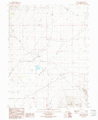
1991 Map of Trout Creek
USGS Topo · Published 1991About this map
Trout Creek serves as a small anchor for this desert landscape, situated within the broad expanse of Snake Valley. The map reveals a history of extraction and utilitarian land use, with several Mine Shafts and scattered Prospects in the northern hills suggesting intermittent mineral exploration. Water is a precious and mapped commodity here, marked by the presence of a Cistern, a Water Tank, and the ephemeral Mile Pond.
Find a feature on this map
19 named features on this map. Tap any name to fly to it.
Don’t see what you’re looking for? This feature index may not catch every label — zoom into the map to look around manually.
Map Details
Editions of this 1991 Trout Creek Map
This is the sole edition of this map. No revisions or reprints were ever made.
Other maps of this area

1908 · Fish Springs
USGS Topo · 1:250,000

1910 · Fish Springs
USGS Topo · 1:250,000

1953 · Delta
USGS Topo · 1:250,000

1958 · Delta
USGS Topo · 1:250,000

1960 · Granite Mountain
USGS Topo · 1:62,500

1961 · Trout Creek
USGS Topo · 1:62,500

1962 · Delta
USGS Topo · 1:250,000

1972 · Mud Lake Reservoir
USGS Topo · 1:24,000
1972 · Ibapah Peak
USGS Topo · 1:24,000
1972 · Indian Farm Creek
USGS Topo · 1:24,000