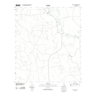
2010 Map of Trout Creek
USGS Topo · Published 2010About this map
Big Cow Creek and Slaydons Creek wind through this corner of the Piney Woods, anchoring a landscape defined by timber and mineral resources in East Texas. The small settlements of Call and Trout Creek are situated in the northern reaches, while Salem lies to the southeast near the Newton Oil Field, reflecting the area's historical connection to the petroleum industry. Further north, Camp Bill Stark and Camp Otanyao sit along the banks of the larger waterways, indicating the region's use for managed recreation and group retreats. The map provides a look at the rural road network, including FM 1004 and FM 82, which connect these dispersed communities. Numerous smaller drainages like Nichols Creek and Little Cypress Creek create a complex watershed, illustrating the dense hydrologic profile characteristic of this humid lowland environment.
Find a feature on this map
23 named features on this map. Tap any name to fly to it.
Don’t see what you’re looking for? This feature index may not catch every label — zoom into the map to look around manually.
Map Details
Editions of this 2010 Trout Creek Map
This is the sole edition of this map. No revisions or reprints were ever made.
Other maps of this area

1935 · Wilson Lake
USGS Topo · 1:31,680

1947 · Carter Creek
USGS Topo · 1:31,680

1947 · Wilson Lake
USGS Topo · 1:31,680

1949 · Bancroft
USGS Topo · 1:31,680

1952 · Lake Charles
USGS Topo · 1:250,000

1954 · Lake Charles
USGS Topo · 1:250,000

1955 · Bessmay
USGS Topo · 1:62,500

1958 · Kirbyville
USGS Topo · 1:62,500
1959 · Starks
USGS Topo · 1:62,500
1959 · Bon Wier
USGS Topo · 1:62,500