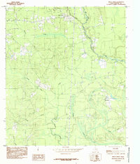
1984 Map of Trout Creek
USGS Topo · Published 1985About this map
The E O Siecke State Forest dominates the northern landscape of this Newton County region, illustrating the importance of managed timberlands in East Texas during the late 1970s and early 1980s. Small settlements like Call and Old Salem are connected by a network of rural roads that navigate a complex system of waterways. This drainage pattern is defined by the winding course of Big Cow Creek and its many tributaries, including Trout Creek and Slaydons Creek. The terrain is characterized by low-lying wetlands and seasonal water features such as Gum Slough and the marsh near Reese Creek. Genealogists and local historians can trace family-named landmarks like Stamps Branch and Simms Branch, which reflect the localized settlement patterns of this heavily forested area during the provisional survey period.
Find a feature on this map
14 named features on this map. Tap any name to fly to it.
Don’t see what you’re looking for? This feature index may not catch every label — zoom into the map to look around manually.
Map Details
Editions of this 1984 Trout Creek Map
This is the sole edition of this map. No revisions or reprints were ever made.
Other maps of this area

1935 · Wilson Lake
USGS Topo · 1:31,680

1947 · Carter Creek
USGS Topo · 1:31,680

1947 · Wilson Lake
USGS Topo · 1:31,680

1949 · Bancroft
USGS Topo · 1:31,680

1952 · Lake Charles
USGS Topo · 1:250,000

1954 · Lake Charles
USGS Topo · 1:250,000

1955 · Bessmay
USGS Topo · 1:62,500

1958 · Kirbyville
USGS Topo · 1:62,500
1959 · Starks
USGS Topo · 1:62,500
1959 · Bon Wier
USGS Topo · 1:62,500