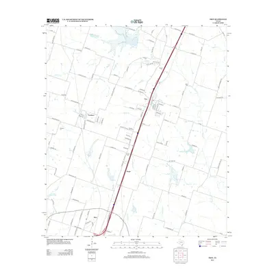
2013 Map of Troy
USGS Topo · Published 2013About this map
The city of Troy anchors this central Texas landscape, positioned along a major transportation corridor between the small communities of Pendleton to the west and Berger to the south. The area is defined by a dense network of country roads and creek drainages, including the branching paths of Little Elm Cr and Big Elm Cr, which transition into open agricultural land and localized clusters of settlement. The map serves as a detailed record of local genealogy and burial sites, marking several historically significant locations such as Old Troy Cem, Shiloh Cem, and Mt Zion Cem. In the southern portion of the sheet, the industrial and residential footprint near Belco shows the continued development of the corridor leading toward the larger urban centers of Bell County. The interplay between these established towns and the smaller family landmarks, such as Roberts Cem and Pleasant View Cem, illustrates the settlement patterns of a region that balances rural legacy with modern infrastructure.
Find a feature on this map
106 named features on this map. Tap any name to fly to it.
Don’t see what you’re looking for? This feature index may not catch every label — zoom into the map to look around manually.
Map Details
Editions of this 2013 Troy Map
This is the sole edition of this map. No revisions or reprints were ever made.
Other maps of this area

1892 · Temple
USGS Topo · 1:125,000

1924 · Temple 2-C
USGS Topo · 1:48,000

1924 · Temple 3-C
USGS Topo · 1:48,000

1924 · Temple 3-B
USGS Topo · 1:48,000

1931 · Mc Gregor
USGS Topo · 1:62,500

1931 · Belton
USGS Topo · 1:62,500

1954 · Waco
USGS Topo · 1:250,000

1955 · Waco
USGS Topo · 1:250,000

1957 · Bruceville
USGS Topo · 1:24,000
1963 · Seaton
USGS Topo · 1:24,000