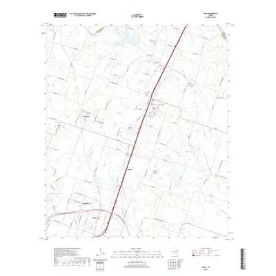
2019 Map of Troy
USGS Topo · Published 2019About this map
Troy and its surrounding rural landscapes in Bell Co are defined by a high concentration of family and community burial grounds, illustrating the deep roots of 19th-century settlement in this part of Texas. Landmarks such as Old Troy Cem, Shiloh Cem, and Roberts Cem are preserved amidst a landscape etched by the drainage of Big Elm Creek and Cottonwood Creek. The transition from rural acreage to the industrial expansion of Temple is visible in the southern portion of the map, where the Belco settlement and Buckshot Ranch Airport sit near the modern NE H K Dodgen Loop. The intersection of traditional geography, like the small community of Pendleton, with modern infrastructure highlights the evolution of the corridor between Waco and Temple. Tributaries including Kings Br and Pecan Cr cut through the terrain, marking the land use patterns that have sustained this region for generations.
Find a feature on this map
107 named features on this map. Tap any name to fly to it.
Don’t see what you’re looking for? This feature index may not catch every label — zoom into the map to look around manually.
Map Details
Editions of this 2019 Troy Map
This is the sole edition of this map. No revisions or reprints were ever made.
Other maps of this area

1892 · Temple
USGS Topo · 1:125,000

1924 · Temple 2-C
USGS Topo · 1:48,000

1924 · Temple 3-C
USGS Topo · 1:48,000

1924 · Temple 3-B
USGS Topo · 1:48,000

1931 · Mc Gregor
USGS Topo · 1:62,500

1931 · Belton
USGS Topo · 1:62,500

1954 · Waco
USGS Topo · 1:250,000

1955 · Waco
USGS Topo · 1:250,000

1957 · Bruceville
USGS Topo · 1:24,000
1963 · Seaton
USGS Topo · 1:24,000