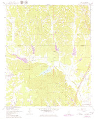
1966 Map of Troy
USGS Topo · Published 1979About this map
The Natchez Trace Parkway cuts a diagonal path through this landscape, marking a historical corridor of travel between Troy and Old Houlka. Much of the southern and central terrain is preserved within the Tombigbee National Forest, where the waters of Chuquatonchee Creek and Davis Creek converge near Davis Lake. This 1960s-era survey reveals a rural landscape deeply rooted in communal landmarks, from the Indian Mounds near Shiloh Ch to a network of family and community burial grounds such as Falkner Cem and Halsey Cem. The drainage patterns of Little Creek and Owl Creek define the ridges and hollows where small settlements and churches like New Salem Ch and Pilgrim Ch organized the local geography. For genealogists and local historians, the map provides a precise layout of rural life before modernization altered the older road and settlement patterns of Chickasaw and Pontotoc counties.
Find a feature on this map
31 named features on this map. Tap any name to fly to it.
Don’t see what you’re looking for? This feature index may not catch every label — zoom into the map to look around manually.
Map Details
Editions of this 1966 Troy Map
3 editions found
Other maps of this area

1953 · West Point
USGS Topo · 1:250,000

1956 · Tupelo
USGS Topo · 1:250,000

1958 · Tupelo
USGS Topo · 1:250,000

1958 · West Point
USGS Topo · 1:250,000

1959 · Van Vleet
USGS Topo · 1:62,500

1963 · West Point
USGS Topo · 1:250,000

1966 · Troy NW
USGS Topo · 1:24,000

1966 · Troy SE
USGS Topo · 1:24,000

1966 · Bissell
USGS Topo · 1:24,000

1966 · Troy
USGS Topo · 1:24,000