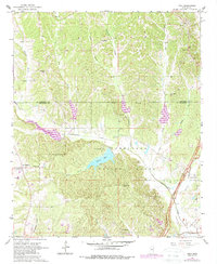
1966 Map of Troy
USGS Topo · Published 1988About this map
Tombigbee National Forest dominates the southern landscape of this mid-1960s survey, illustrating the intersection of conserved timberlands and deep-rooted rural settlements. The terrain is defined by a dense network of tributaries including Little Goodfood Creek and Chuquatonchee Creek, which feed into the central Davis Lake. The map reveals a transition in settlement patterns between Old Houlka and the newer Houlka to the west, while the historic Natchez Trace Parkway cuts through the southeastern corner. Local genealogy and community history are well-preserved through numerous rural landmarks such as Toxish Ch, Shiloh Ch, and the Falkner Cem. Of particular archaeological interest is the notation of Indian Mounds located near the forest boundary, signaling long-standing human presence in this Chickasaw County region.
Find a feature on this map
36 named features on this map. Tap any name to fly to it.
Don’t see what you’re looking for? This feature index may not catch every label — zoom into the map to look around manually.
Map Details
Editions of this 1966 Troy Map
3 editions found
Other maps of this area

1953 · West Point
USGS Topo · 1:250,000

1956 · Tupelo
USGS Topo · 1:250,000

1958 · Tupelo
USGS Topo · 1:250,000

1958 · West Point
USGS Topo · 1:250,000

1959 · Van Vleet
USGS Topo · 1:62,500

1963 · West Point
USGS Topo · 1:250,000

1966 · Troy NW
USGS Topo · 1:24,000

1966 · Troy SE
USGS Topo · 1:24,000

1966 · Bissell
USGS Topo · 1:24,000

1966 · Troy
USGS Topo · 1:24,000