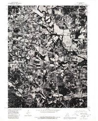
1979 Map of Troy
USGS Topo · Published 1980About this map
Troy serves as the focal point of this orthophotoquad, which captures the Lincoln County landscape through rectified aerial imagery. The settlement patterns of the late 1970s are clearly visible, showcasing the residential and commercial expansion of the town alongside the winding course of the Cuivre River. To the southeast, the smaller community of Moscow Mills appears at a strategic bend in the river, highlighting the historic reliance on these waterways for early industry and transport. The imagery is overlaid with traditional land lines, including the north-south alignment of the Fifth Principal Meridian, which dictates the region's surveying history. Further south, Big Creek meanders through a mix of dense woodlots and agricultural fields, revealing the environmental transition between the river bottoms and the surrounding Missouri uplands.
Find a feature on this map
5 named features on this map. Tap any name to fly to it.
Don’t see what you’re looking for? This feature index may not catch every label — zoom into the map to look around manually.
Map Details
Editions of this 1979 Troy Map
This is the sole edition of this map. No revisions or reprints were ever made.
Other maps of this area

1890 · Louisiana
USGS Topo · 1:125,000

1890 · Hermann
USGS Topo · 1:125,000

1903 · O'Fallon
USGS Topo · 1:125,000

1934 · Elsberry
USGS Topo · 1:48,000

1937 · Silex
USGS Topo · 1:62,500

1939 · Silex
USGS Topo · 1:48,000

1941 · Troy
USGS Topo · 1:62,500

1942 · Elsberry
USGS Topo · 1:62,500

1943 · Warrenton
USGS Topo · 1:62,500

1945 · Troy
USGS Topo · 1:62,500