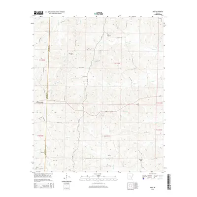
2014 Map of Troy
USGS Topo · Published 2014About this map
The rolling woodlands of the Arkansas timberlands define this landscape along the county line between Nevada and Ouachita Counties. Centered on the community of Troy, the terrain is heavily dissected by slow-moving waterways such as Lewis Bayou, White Oak Creek, and the winding Cypress Creek. The economy and land use are characterized by the East Troy Oil Field and a network of county roads like AR 57 Highway and Us-278 that connect small settlements. Local history is anchored by several rural burying grounds including Adams Chapel Cemetery, Hickory Ridge Cemetery, and Zion Hill Cemetery, which serve as landmarks for the dispersed population of Spring Hill and Mendenhall. The map reveals a transition from traditional agriculture to energy extraction and forestry as the primary drivers of the local geography.
Find a feature on this map
53 named features on this map. Tap any name to fly to it.
Don’t see what you’re looking for? This feature index may not catch every label — zoom into the map to look around manually.
Map Details
Editions of this 2014 Troy Map
This is the sole edition of this map. No revisions or reprints were ever made.
Other maps of this area

1901 · Gurdon
USGS Topo · 1:125,000

1903 · Camden
USGS Topo · 1:125,000

1953 · El Dorado
USGS Topo · 1:250,000

1957 · El Dorado
USGS Topo · 1:250,000

1958 · El Dorado
USGS Topo · 1:250,000

1960 · El Dorado
USGS Topo · 1:250,000

1962 · Buena Vista
USGS Topo · 1:24,000

1964 · Louann
USGS Topo · 1:62,500
1969 · Stephens
USGS Topo · 1:24,000
1969 · Magnolia NW
USGS Topo · 1:24,000