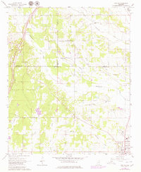
1966 Map of Troy SE
USGS Topo · Published 1979About this map
The Tombigbee National Forest dominates the western landscape of this Northeast Mississippi quadrangle, where the Natchez Trace Parkway cuts a diagonal path through the timber and terrain. The map captures a rural social fabric defined by its small country congregations and burial grounds, such as Union Chapel, Prairie Mount Ch, and Snow Town Ch, which anchor the dispersed settlements across the Lee, Chickasaw, and Pontotoc county lines. These small institutions reflect the localized community structure of the mid-20th century before greater regional consolidation.
Find a feature on this map
36 named features on this map. Tap any name to fly to it.
Don’t see what you’re looking for? This feature index may not catch every label — zoom into the map to look around manually.
Map Details
Editions of this 1966 Troy SE Map
3 editions found
Other maps of this area

1953 · West Point
USGS Topo · 1:250,000

1956 · Tupelo
USGS Topo · 1:250,000

1958 · Tupelo
USGS Topo · 1:250,000

1958 · West Point
USGS Topo · 1:250,000

1959 · Van Vleet
USGS Topo · 1:62,500

1963 · West Point
USGS Topo · 1:250,000

1965 · Egypt
USGS Topo · 1:24,000

1966 · Shannon
USGS Topo · 1:24,000

1966 · Troy NW
USGS Topo · 1:24,000

1966 · Troy SE
USGS Topo · 1:24,000