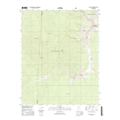
2017 Map of Truchas Peak
USGS Topo · Published 2017About this map
High-elevation peaks and alpine watersheds dominate this 2017 survey of the Santa Fe National Forest and Carson National Forest border. The terrain is anchored by a cluster of prominent summits, including Truchas Peak, Mid Truchas Peak, and N Truchas Peak, forming a high ridgeline that separates the drainage systems of the Rio Medio and Rio Quemado. This area marks a critical divide where the Santa Fe Mountains meet the broader Sangre de Cristo Mountains, with elevations reaching well above the timberline. Scattered throughout these high basins are remote water bodies such as Truchas Lakes and Jose Vigil Lake, which feed a complex network of headwaters including the N-Fork Rio Quemado and S-Fork Rio Quemado. To the south, the landscape transitions toward Pecos Baldy and East Pecos Baldy, where the Pecos Baldy Lake sits below the distinctive geologic formation of Traitriders Wall.
Find a feature on this map
36 named features on this map. Tap any name to fly to it.
Don’t see what you’re looking for? This feature index may not catch every label — zoom into the map to look around manually.
Map Details
Editions of this 2017 Truchas Peak Map
This is the sole edition of this map. No revisions or reprints were ever made.
Other maps of this area

1889 · Santa Fe
USGS Topo · 1:125,000

1894 · Santa Fe
USGS Topo · 1:125,000

1953 · Truchas
USGS Topo · 1:24,000

1953 · Sierra Mosca
USGS Topo · 1:24,000

1953 · Aspen Basin
USGS Topo · 1:24,000

1954 · Santa Fe
USGS Topo · 1:250,000

1954 · Raton
USGS Topo · 1:250,000

1958 · Raton
USGS Topo · 1:250,000

1958 · Santa Fe
USGS Topo · 1:250,000
1961 · Cowles
USGS Topo · 1:24,000