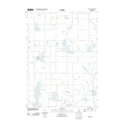
2011 Map of Trufant
USGS Topo · Published 2011About this map
Trufant and Gowen anchor this portion of Montcalm County, centered on a glacial landscape defined by dozens of kettle lakes. The settlement of Trufant is clustered around Muskellunge Lake, featuring its own post office and cemetery. To the south, Gowen sits along the winding Flat River, which carves a distinct path through the southeastern corner of the map. The area's cultural history is reflected in names like the Little Denmark Cemetery, hinting at the heritage of early settlers who established these communities. Notable recreational and community spaces like Camp Anna Behrens, Pleasant Hill Camp, and the Brookside Golf Course occupy the land between the water bodies, while a dense grid of rural roads such as W Waterwheel Rd and Coral Rd connects the scattered lakeside residences and farmsteads.
Find a feature on this map
76 named features on this map. Tap any name to fly to it.
Don’t see what you’re looking for? This feature index may not catch every label — zoom into the map to look around manually.
Map Details
Editions of this 2011 Trufant Map
This is the sole edition of this map. No revisions or reprints were ever made.
Other maps of this area

1954 · Midland
USGS Topo · 1:250,000

1958 · Midland
USGS Topo · 1:250,000

1959 · Midland
USGS Topo · 1:250,000

1959 · Howard City
USGS Topo · 1:62,500

1964 · Six Lakes
USGS Topo · 1:24,000

1964 · Langston
USGS Topo · 1:24,000

1966 · Midland
USGS Topo · 1:250,000

1972 · Greenville West
USGS Topo · 1:24,000
1972 · Greenville East
USGS Topo · 1:24,000
1972 · Evans
USGS Topo · 1:24,000